SIMP is a nationally recognized and adopted platform for performing analysis on biocontrol release sites. The data captured is used to document vegetation cover, target weed density, and biological control agent abundance. When conducted annually, this monitoring data will document changes that occur over time.
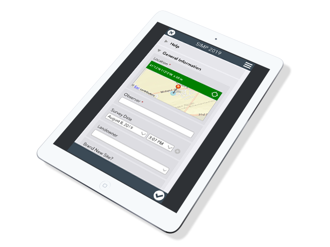
Utilizing Survey 123 and our SIMP app land managers can record and map all of their data. We even have web based forms for past years entries.
All data is synced to the online map below for immediate view. See your sites and overlay them with existing map layers.
Monitoring biological control agents is an essential component of a successful biological control program. Capturing this data helps us accurately document the impact of this weed management practice. Learn more about the permanent monitoring system.
Use our online form to enter data directly from your computer. Have data that needs to be entered from past years? Here is the solution. Select the browser option from the link below. The form does not allow photo submissions; to have them attached to your points, use the button to email them directly.
Once you have made the choice to conduct regular monitoring on your biocontrol sites, get to know the available tools.
Once you have established your monitoring site, committing to regular annual monitoring will give you the best analysis data over time. You’ll be able to see site numbers and compare them from year to year.
Once you use the app or the online form to enter in your data, results are synced with the online map (above). You can see the data in real time. You can look at other SIMP sites, overlay map layers, look at soil, precipitation, and slope for your areas. To begin your analysis, use the map tools to create reports with interactive charts and graphs comparing years. Print the site report when you are ready and include your graphs, complete with a map of the area.
You select the “continue without signing in” option below the “Sign in with ArcGIS Online” and “Manage ArcGIS connections” options.
Remember to delete prior year Survey 123 SIMP forms before downloading this year’s form.
Yes. Funding for the development and implementation has been provided through cost sharing grants from the Idaho Dept of Ag and Forest Service. The SIMP application is free to use and we encourage all users to take advantage of the free tools inside the online map.
Unless more in-depth information is desired for specific sites, it is recommended that SIMP sites should be at least 10 miles apart as ecotypes do not fluctuate to extremes within ecotones.
Monitoring is best done during peak emergence of the biocontrol agent. This varies by location and by year, but general guidelines have been created and can be found in the 2-page outlines for each system to address likely ideal windows for monitoring in your respective area.
Once you have established your monitoring site, committing to regular annual monitoring will give you the best analysis data over time. You’ll be able to see site numbers and compare them from year to year.
A sweep is one arc of the sweep net.
Yes, there is an “immature” category for this so the stem counts for mature and immature plants within a frame will be separate.
Rock is bare ground. Soil, by definition is simply decayed organic matter with varying degrees of ground up rock. If it is organic it is litter if not it is bare ground.
Lichen is considered in the “moss” category unless it is on a rock in which case it should be considered bare ground.
This year’s organic matter (green earlier in the year) should be considered vegetation. Last year’s senesced growth should be considered litter.
A rosette is counted as a stem. Seedlings or germinants should be counted in the “immature stem” category.
Take the longest rosette leaf and note that the target weed is in the rosette stage in comments. Ideally, there would not be height measurements done unless the plant is in bloom as this typically coincides with peak emergence of the biocontrol agents.
If the weed is transient across the field, consider investing the time to have two or three SIMP transects across the site and lump the data. Empty frames are important. If the placement of the transect can account for the edges of the infestation, if the patch is not declining but merely shifting across the landscape, those empty frames will fill and your overall density will remain constant, telling the story of weed persistence. These data are also captured in the estimated infestation size and can also be addressed in the notes.
Sedges and rushes should be considered perennial grasses in this monitoring approach.